Combining real-time AIS with vessel detections by satellite for surveillance of an area of interest
In May 2020 Starboard set out to provide an enhanced picture of southern bluefin tuna fisheries in the Tasman Sea.
Southern bluefin tuna, one of the world’s most valuable commercial fish stocks, have served as an unfortunate reminder of the negative impact of overfishing on the high seas. The species was deemed critically endangered in 2009 after it was estimated that the fishery was at just 10 percent total reproductive output (TRO 1) compared to unfished levels 2.
Appropriate management of the migratory southern bluefin tuna–which travel thousands of kilometres in their lifetime–is vital to protect not only the oceans but also those that rely on this tuna species for their livelihoods.
This management is delivered through the Commission for the Conservation of Southern Bluefin Tuna (CCSBT), an intergovernmental organisation which administers the global catch limits as well as provides monitoring, control and surveillance (MCS) frameworks for the eight countries that participate as extended members.
Stock assessments in recent years have shown that the species has recovered to 20 percent TRO, relative to the unfished population 3, due in part to this collaborative effort.
An important part in managing the sustainable use of fisheries is the ongoing work to eliminate Illegal, Unreported and Unregulated fishing (IUU), an issue on which Starboard Maritime Intelligence is focused.
What are some of the current methods of surveillance in an MCS framework?
Analysts look for things such as vessels meeting at sea, vessels being at sea for a long time, or patterns indicating the automatic identification system (AIS) transponder is being disabled. Analysts also review the ownership structures for a vessel, examine any previous transgressions, and reference authorisation details from regional fisheries management organisations (RFMOs) such as the Western and Central Pacific Fisheries Commission WCPFC and the CCSBT.
These factors, along with other intelligence sources, help an analyst prioritise their recommendations for which vessels should be investigated further. This investigation may include the collection of evidence through aerial surveillance and boarding if IUU fishing is suspected.
Traditional surveillance analysis in the Tasman Sea has relied upon vessels reporting their location through the WCPFC vessel monitoring system (VMS) or having an AIS operating. Vessels that choose to be uncooperative or ‘dark’ often remain unseen or undetected by switching off their VMS or AIS.
The use of space-based vessel detection technologies such as those offered by MDA (RADARSAT-2) and Unseenlabs (radio frequency geolocation) provide another option for maritime surveillance and can help to uncover these dark vessels.
Using satellites for fisheries monitoring, control and surveillance
New satellite capabilities and data science techniques enable monitoring of vast areas of the ocean–previously not possible using aerial and surface assets–and the detection of dark vessels through the fusion of multiple information sources.
For several years, the team at Starboard has been actively researching how to use satellite data to assist with vessel detection. Each data type has its advantages and disadvantages when it comes to finding vessels. Knowing which is the best to use for the conditions is key to successfully monitoring the maritime domain.
The Starboard platform automatically ingests, processes, and analyses four types of satellite data used to detect vessels.
| Sources of satellite observations: | How it works: | |
|---|---|---|
| AIS | Automatic Identification System | Receiving self-reported vessel transponder information like name, location, speed, and direction of travel. |
| RF | Radio Frequency | Mapping of RF emitters across a wide area of ocean, picking up the presence of navigational radars and radio communication systems. |
| SAR | Synthetic-aperture radar | ‘Illuminating’ a wide area of ocean with radio waves and recording the backscatter/echoes to detect vessels (especially those made of metal) irrespective of weather. |
| Optical | Optical imaging | Photographing a smaller area of the ocean using the visible and near-infrared spectrum. |
There are several providers available for each of these sources of satellite data and they are continually working to improve their technologies and processes.
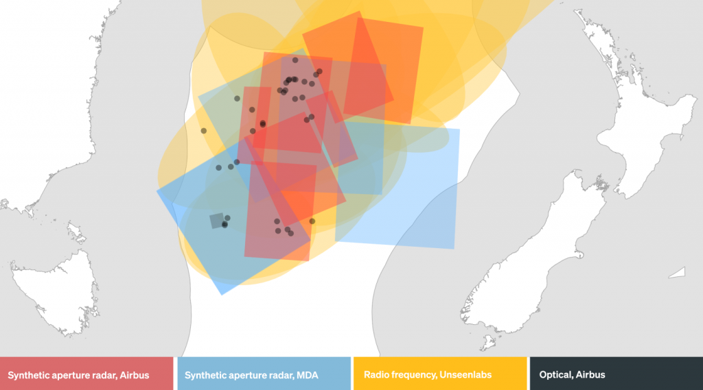
For the 2020 Tasman Sea operation a combination of these was used including Airbus, MDA and Unseenlabs. The providers were chosen based both on their coverage for our area of interest and their ability to detect fishing vessels.
What changes are occuring in the space data market ?
The team behind Starboard are seeing ongoing improvements throughout the industry for both the availability and the quality of Earth observation data. This holds true within the maritime sector where we see continued momentum from several high-performing providers.
An example is Unseenlabs, who are launching improved RF detection satellites as they grow their constellation. Across the past two years not only has Unseenlabs’ frequency of coverage improved but also their data quality has been enhanced.
In the SAR market, growth has been centred on satellite constellations, with frequent revisit rates and very high-resolution imagery (<0.5m) 4. Providers of these sensors include Capella, ICEYE and Synspective. These have relatively small coverage areas, however, so we chose MDA and its RADARSAT-2 satellite for this surveillance operation in the expansive area of the Tasman Sea.
We are looking forward to potential future applications of these SAR satellite constellations for Starboard. Their frequent revisit rates could enable realistic multi-sensor tip-n-cue acquisitions if the commercial tasking process can be further automated. In this scenario, Starboard could analyse activity in a large maritime area and then cue additional sensors for more targeted acquisitions with higher resolution.
Combined constellations are another option for the future of tip-n-cue applications. In late 2021 MDA announced the addition of a high-resolution X-Band satellite into their CHORUS constellation. This constellation, which is currently under development, will have a powerful C-Band SAR satellite and include the X-Band satellite trailing 1-hour behind the C-Band satellite for tip-n-cue operations. To provide more frequent daily revisits, these satellites would be put into an inclined orbit–not the traditional polar orbit–providing multiple imaging opportunities over most areas of interest globally.
We are excited to work again with both Unseenlabs and MDA on another surveillance operation in May 2022. Learn more →
Preparing for a satellite surveillance operation
Satellites collecting RF, SAR and optical data cannot continuously observe the entire planet. You need to have them tasked–directed to collect the data you require–as they make an overpass of your area of interest.
Part of learning how to use the different types of satellite data successfully is understanding which data are most suited, as well as knowing when and where to look. Once you know this you can work with satellite data providers to task a satellite for your data collection.
It requires precision and planning to get these requests right, especially over the large expanse of the ocean.
Prior to the Tasman Sea operation in 2020 we spent much time in preparation and investigated the previous five years of fishing activity. The result of this work helped us determine which flag states would likely be fishing in the area of interest, and what their historical fishing activity looked like.
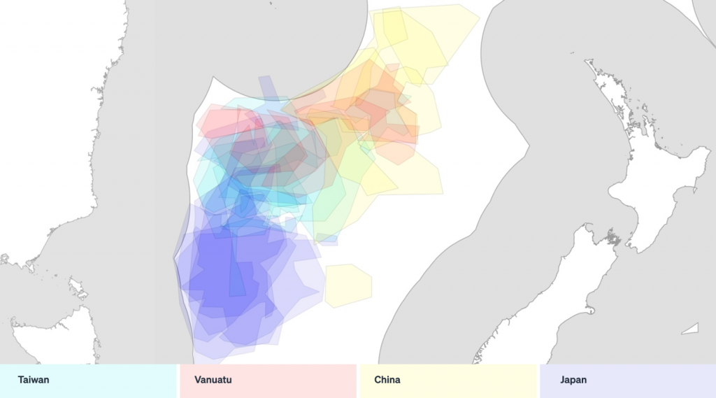
With historical fishing activity as a guide, we were able to task multiple satellite sensors to ensure we were targeting the projected areas of high activity repeatedly over the two-week operation.
Can preparation for a surveillance operation be done in Starboard ?
Starboard has matured a lot since it was beta tested in 2020 and analysis prior to an operation can now be completed in the application.
Preparing for an operation can take less than a day with analytics tools designed specifically for fishing including our fishing classifier, advanced filtering and the beta release of vessel lists from RFMOs like WCPFC and CCSBT. Coming soon is the addition of a sea surface temperature layer, which is a key driver for fishing behaviour targeting migratory species like southern bluefin tuna.
The day to day running of a satellite surveillance operation
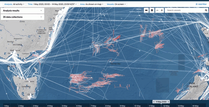
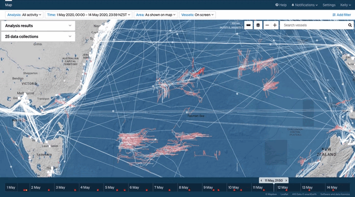
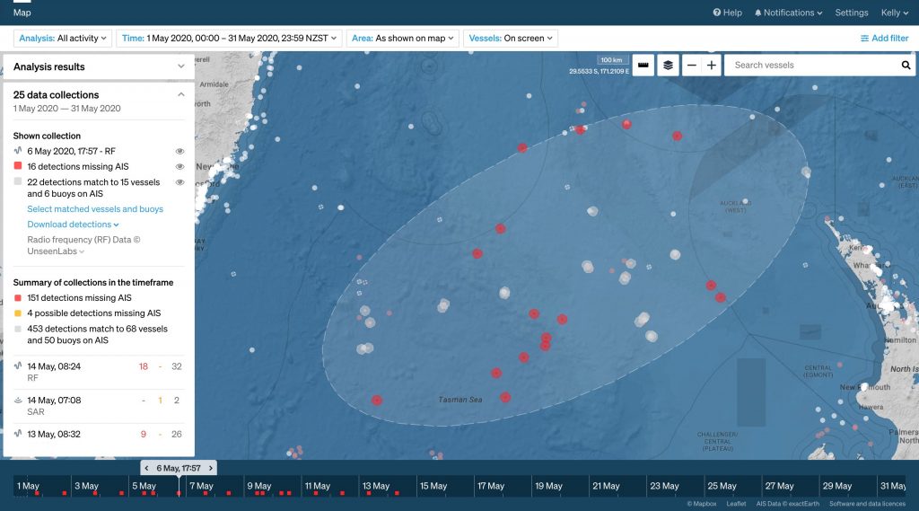
Each day we were able to monitor an area of 760,000 km2, more than twice the landmass of Aotearoa New Zealand. Over the 14 days of the operation we accumulated data covering nearly 11 million km2 of the ocean.
To achieve this scale of monitoring, there were on average two satellite data collections made each day—a total of 25 over the May 1-14 operation.
The satellite information gathered was viewed in real-time, with a daily 4pm briefing to further discuss the new data gathered during the prior 24 hours. Insights included fishing activity, vessels entering the area of interest (AOI), and–through the fused satellite data–identification of dark vessels. Additional sources of information such as sea surface temperature (which affects tuna movements) were also taken into account.
Satellite surveillance operations offer a lower cost method to illuminate activity in distant waters, and are an effective way to direct aerial and surface assets to inspect vessels of interest.
Here’s what we uncovered during the surveillance operation:
| Detections with AIS matching |
|---|
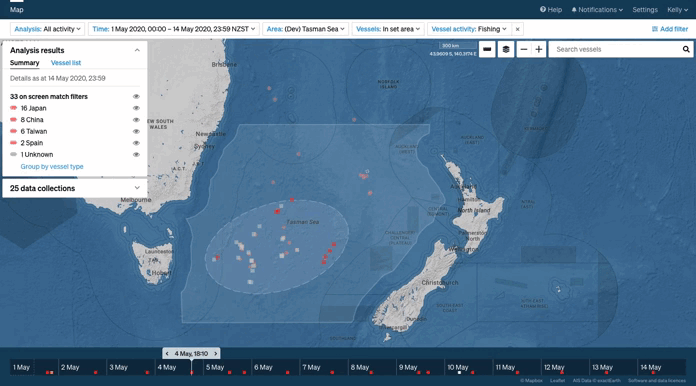
| 30 vessels fishing and reporting on AIS from 4 flag states. |
| 28 of these were on the WCPFC record of vessels and 18 were in the CCSBT database. |
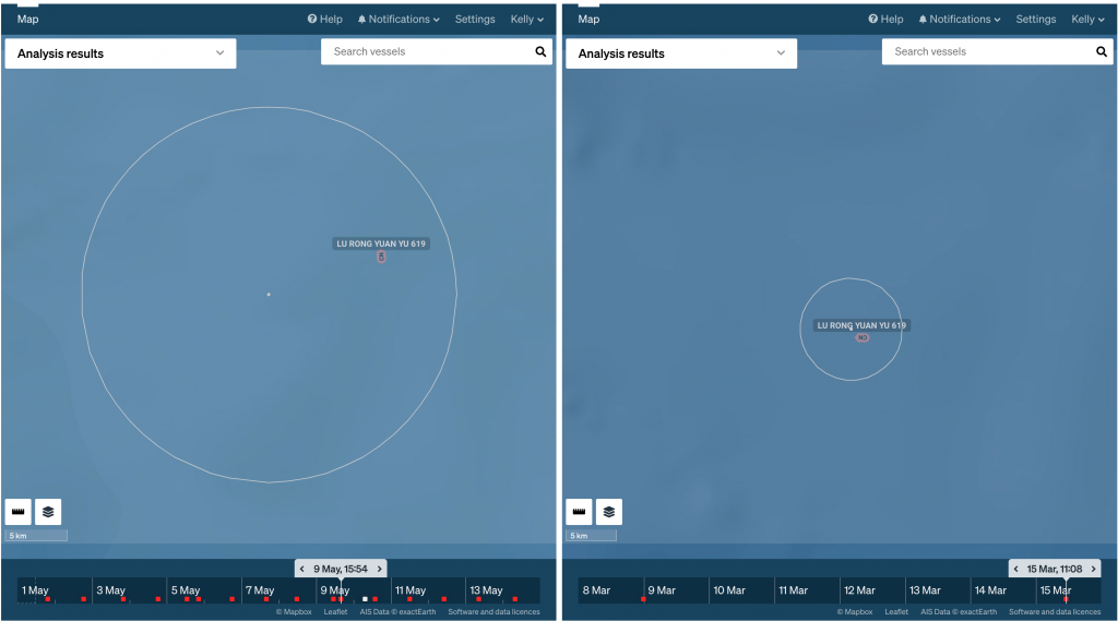
| 29 out of the 30 vessels were detected on SAR, RF, or optical at least once during the operation. |
| Detections without AIS matching |
|---|
| 147 RF detections, which may include potential dark vessels or buoys being detected multiple times during the operation. |
| 4 potential dark vessel detections using SAR. |
| 2 potential dark vessel detections using optical imagery. |
| 1 dark fleet detected multiple times in an area that had a sea temperature where southern bluefin tuna are likely to be found. |
Join us for our next surveillance operation
Starboard Maritime Intelligence, Unseenlabs and MDA (RADARSAT-2) will be at the Indo Pacific International Maritime Exposition in May 2022. We will be hosting Operation 18c, a joint demonstration of satellite surveillance, live at the event and also online for those not attending in person.
Learn more about how to plan, task and analyse satellite intelligence in the search for illegal fishing.